


 Business
The Stock Market
Japanese firms test satellite-based info system on NLEX roads
Business
The Stock Market
Japanese firms test satellite-based info system on NLEX roads
Japanese firms test satellite-based info system on NLEX roads


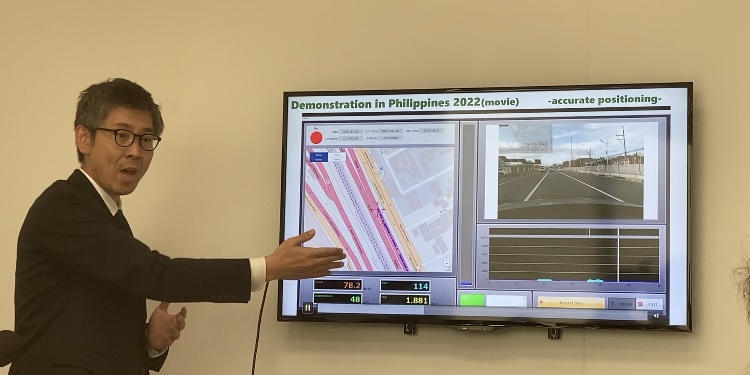
Japanese infrastructure solutions firms Pacific Consultants Co. Ltd and Oriental Consultants Global Co. Ltd said their demonstration experiment on a satellite-based road surface information system for the North Luzon Expressway (NLEX) yielded positive results in ease of collecting data on critical road conditions.
Pacific Consultants and Oriental Global embarked on a two-year project in the Philippines, through a memorandum of understanding (MOU) with NLEX Corporation, for a lane-by-lane road information system that would measure location information with centimeter-level accuracy and road surface roughness using sensors installed on vehicles and Japan's satellite positioning system called MICHIBIKI.
MICHIBIKI consists of satellites in quasi-zenith orbit that hover between the zenith of Japan and Australia, which supplements the global navigation satellite system (GNSS). It is also able to provide accurate and stable satellite positioning services at low costs.
This system promises a centralized system that can swiftly detect potholes and other road damages along the whole stretch of the expressway. This will reduce the costs incurred by physical inspections, as well as maintenance costs since the system can predict road deterioration and set optimal timelines for repairs.
It also enables data collection and analysis in real time, which prevents data from becoming obsolete over time.
The demonstration project was done and funded under contract with the Ministry of Internal Affairs and Communications of Japan (MIC).
Test runs were conducted in October last year and February this year. The cost for the study this year was around 40 million yen, excluding tax.
Oriental Consultants Global Deputy General Manager Soichiro Hayashi told reporters in a press conference on Feb. 8 that the Philippines was an ideal location to conduct the study given it geographical advantage in accessing the MICHIBIKI signal, and the emerging market.
Aside from road roughness, the system can also measure road elevation, which can be particularly useful to address concerns on flooding.
Despite the demonstrations proving the functionality and efficiency of the system on Philippine roads, traffic was seen as a particular challenge to acquiring accurate data due to the slow movement of vehicles.
Nonetheless, NLEX was interested in their technology and harnessing it for their business, he noted.
NLEX Corp. has not yet acquired the system itself, but Hayashi shared they are continuously engaged in sharing data and information with the concessionaire to jointly develop the system. NLEX Corp. has also provided engineers to assist the firms on the project.
"If our data has a correlation between their own data, if it's matching, they can use our system to monitor and report it as [NLEX]'s concessionaire and to the government. If they can use our technology system, that would be very nice," he said.
Their contract with the Japanese government for the project in the Philippines ends this March, but research and development (R&D) cooperation with NLEX Corp will continue with other possible engagements.
Hayashi said they also hope to extend their study and partnership with NLEX Corp as it expands the expressway. He noted Metro Pacific Tollways Corporation (MPTC), the parent company of NLEX Corp., as a potential partner as well.
Moreover, Hayashi said it has also talked with the Metro Manila Development Authority (MMDA) on possible use of the system.
As a business, the two firms are open to potential collaboration with government agencies in the future, especially with the support of other Japanese agencies like the Japan International Development Agency (JICA).
Pacific Consultants Technical Manager and Project Leader Shusaku Nakamura and First Secretary Akihito Hitomi of the Embassy of Japan in the Philippines were also present during the media briefing.
"The government of Japan, together with Japanese business, is committed to be a partner in the digitalization of the Philippine society," said Hitomi.